The nycxwalks package provides crosswalk tables for fifteen New York City geographies. The tables show how the geographies overlap. The geographies are:
- community districts, police precincts, sanitation districts, fire battalions, school districts, and health center districts
- city council, congressional, state assembly, and state senate districts
- business improvement districts, historic districts, and industrial business zones
- Neighborhood Tabulation Areas (NTAs) and Modified ZIP Code Tabulation Areas
For each pair of features that overlap, the tables give the area of the overlap and the share of each feature that the overlap covers. Use these shares to move data from one geography to another. The package also includes the boundaries that nycbuildxwalks used to compute the tables.
nycbuildxwalks built the tables. nycbuildxwalks is an R port of the Python NYC geography crosswalks tool by Nathan Storey at MODA-NYC. That tool builds on the concepts and data aggregation methods of the BetaNYC NYC Boundaries Map. The boundaries come from the NYC Department of City Planning, NYC Open Data, and the NYC Economic Development Corporation. nycbuildxwalks downloaded them on 2026-10-24.
Installation
You can install the development version of nycxwalks from GitHub with:
# install.packages("pak")
pak::pak("kjhealy/nycxwalks")What’s included
nyc_xwalk_geographies_df |>
  select(geo_id, geo_name, source, cycle, n_names)
#> # A tibble: 15 × 5
#>    geo_id     geo_name                           source            cycle n_names
#>    <chr>      <chr>                              <chr>             <chr>   <int>
#>  1 cd         Community Districts                NYC Department o… 25d        71
#>  2 pp         Police Precincts                   NYC Department o… 25d        78
#>  3 dsny       Sanitation Districts               NYC Open Data     <NA>       59
#>  4 fb         Fire Battalions                    NYC Department o… 25d        49
#>  5 sd         School Districts                   NYC Department o… 25d        32
#>  6 hc         Health Center Districts            NYC Department o… 25d        30
#>  7 cc         City Council Districts             NYC Department o… 25d        51
#>  8 nycongress Congressional Districts            NYC Department o… 25d        13
#>  9 sa         State Assembly Districts           NYC Department o… 25d        65
#> 10 ss         State Senate Districts             NYC Department o… 25d        28
#> 11 bid        Business Improvement Districts     NYC Open Data     <NA>       76
#> 12 nta        Neighborhood Tabulation Areas      NYC Department o… 25d       262
#> 13 zipcode    Modified ZIP Code Tabulation Areas NYC Open Data     <NA>      178
#> 14 hd         Historic Districts                 NYC Open Data     <NA>      141
#> 15 ibz        Industrial Business Zones          NYC Economic Dev… <NA>       21
The long-format crosswalk has one row for each pair of overlapping features. pct_overlap gives the overlap as a share of the primary feature. pct_of_other gives the overlap as a share of the other feature.
nyc_xwalk_df
#> # A tibble: 38,323 × 9
#>    primary_geo_id primary_geo_name other_geo_id other_geo_name primary_area_sqft
#>    <chr>          <chr>            <chr>        <chr>                      <dbl>
#>  1 cd             101              pp           1                      41697017.
#>  2 cd             101              pp           5                      41697017.
#>  3 cd             101              dsny         MN01                   41697017.
#>  4 cd             101              dsny         MN03                   41697017.
#>  5 cd             101              fb           1                      41697017.
#>  6 cd             101              fb           2                      41697017.
#>  7 cd             101              sd           2                      41697017.
#>  8 cd             101              hc           15                     41697017.
#>  9 cd             101              cc           1                      41697017.
#> 10 cd             101              nycongress   10                     41697017.
#> # ℹ 38,313 more rows
#> # ℹ 4 more variables: other_area_sqft <dbl>, intersection_area_sqft <dbl>,
#> #   pct_overlap <dbl>, pct_of_other <dbl>
The wide-format crosswalk lists, for each feature, the overlapping features in every other geography.
nyc_xwalk_wide_df
#> # A tibble: 1,154 × 17
#>    primary_geo_id primary_geo_name cd    pp        dsny  fb    sd    hc    cc
#>    <chr>          <chr>            <chr> <chr>     <chr> <chr> <chr> <chr> <chr>
#>  1 cd             101              <NA>  1;5       MN01… 1;2   2     15    1
#>  2 cd             102              <NA>  1;5;6;9   MN02  2;4;6 2     15    1;2;3
#>  3 cd             103              <NA>  5;7;9     MN03  1;2;… 1;2   14;15 1;2
#>  4 cd             104              <NA>  10;13;14… MN04  10;7… 2;3   15    3;6
#>  5 cd             105              <NA>  10;13;14… MN05  6;7;… 2     13;1… 2;3;…
#>  6 cd             106              <NA>  13;17     MN06  4;6;8 2     13;1… 2;4;5
#>  7 cd             107              <NA>  20;24     MN07  11;9  3     15;16 6;7
#>  8 cd             108              <NA>  114;19;25 MN08  10;45 2     12;13 4;5;8
#>  9 cd             109              <NA>  26;30     MN09  11;1… 3;5;6 16;17 7;9
#> 10 cd             110              <NA>  28;30;32… MN10  11;1… 3;5;6 11;17 9
#> # ℹ 1,144 more rows
#> # ℹ 8 more variables: nycongress <chr>, sa <chr>, ss <chr>, bid <chr>,
#> #   nta <chr>, zipcode <chr>, hd <chr>, ibz <chr>
nyc_xwalk_boundaries_sf has the boundaries, in EPSG:2263.
nyc_xwalk_boundaries_sf
#> Simple feature collection with 1155 features and 3 fields
#> Geometry type: MULTIPOLYGON
#> Dimension:     XY
#> Bounding box:  xmin: 913175.1 ymin: 120121.9 xmax: 1067383 ymax: 272844.3
#> Projected CRS: NAD83 / New York Long Island (ftUS)
#> First 10 features:
#>    geo_id geo_name geo_name_alt                       geometry
#> 1      cd      101         <NA> MULTIPOLYGON (((979992 1918...
#> 2      cd      102         <NA> MULTIPOLYGON (((981751 2097...
#> 3      cd      103         <NA> MULTIPOLYGON (((987359.7 20...
#> 4      cd      104         <NA> MULTIPOLYGON (((985929.3 22...
#> 5      cd      105         <NA> MULTIPOLYGON (((991725.2 21...
#> 6      cd      106         <NA> MULTIPOLYGON (((994964.3 20...
#> 7      cd      107         <NA> MULTIPOLYGON (((995422.2 23...
#> 8      cd      108         <NA> MULTIPOLYGON (((1000158 219...
#> 9      cd      109         <NA> MULTIPOLYGON (((1000815 241...
#> 10     cd      110         <NA> MULTIPOLYGON (((1002388 243...
Example: NTAs in a community district
nyc_xwalk() returns the crosswalk between two geographies. Here are the Neighborhood Tabulation Areas that make up Brooklyn Community District 6, keeping overlaps of at least 1% of the district.
Example: apportioning to another geography
To move a count from one geography to another, divide the count of each source feature among the target features. Use the intersection areas as the weights. Then add the results for each target feature. Because of the 50 ft buffer, the pct_overlap values of a feature add up to slightly less than 100. The example below rescales the intersection areas of each source feature to sum to one, so the total count does not change. This method assumes that the count is spread evenly over the area of each source feature. The example moves counts from police precincts to community districts:
precinct_counts <- tibble(
  precinct = c("77", "78", "88"),
  n = c(1200, 950, 700)
)

nyc_xwalk("pp", "cd") |>
  inner_join(precinct_counts, by = c("primary_geo_name" = "precinct")) |>
  mutate(
    weight = intersection_area_sqft / sum(intersection_area_sqft),
    .by = primary_geo_name
  ) |>
  summarise(n = sum(n * weight), .by = other_geo_name) |>
  arrange(desc(n))
#> # A tibble: 5 × 2
#>   other_geo_name          n
#>   <chr>               <dbl>
#> 1 308            1241.
#> 2 302             718.
#> 3 306             527.
#> 4 355             364.
#> 5 307               0.00731
Example: a map
Brooklyn Community District 6 and the NTAs that overlap it.
nta_names <- nyc_xwalk("cd", "nta", min_pct = 1) |>
  filter(primary_geo_name == "306") |>
  pull(other_geo_name)

ntas <- nyc_xwalk_boundaries_sf |>
  filter(geo_id == "nta", geo_name %in% nta_names)

cd6 <- nyc_xwalk_boundaries_sf |>
  filter(geo_id == "cd", geo_name == "306")

ggplot() +
  geom_sf(data = ntas, aes(fill = geo_name), color = "white") +
  geom_sf(data = cd6, fill = NA, color = "black", linewidth = 0.8) +
  labs(
    fill = "NTA",
    title = "Brooklyn Community District 6 and its NTAs"
  ) +
  theme_void()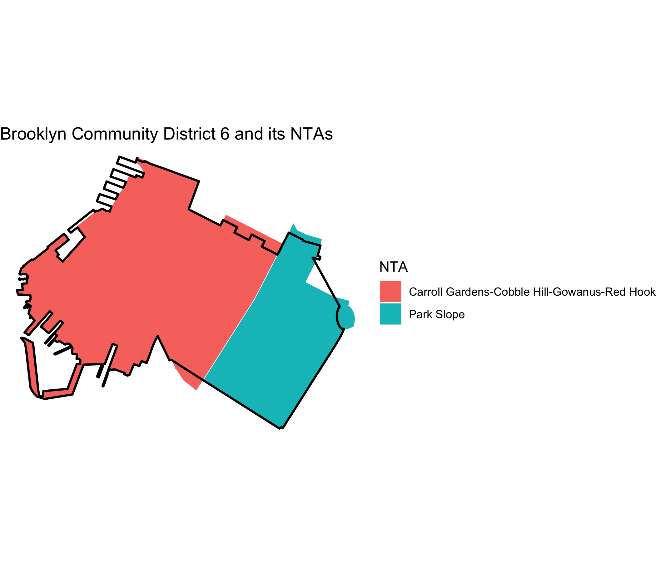
Methodology
- Dissolving: nycbuildxwalks combines features with the same name before it computes overlaps.
- De-noising: nycbuildxwalks shrinks each primary feature by 50 feet (a negative buffer) before it intersects the features. It drops overlaps of 100 square feet or less. Thus the two directions of a pair (for example, CD-to-NTA and NTA-to-CD) can differ slightly.
- Narrow features: five very narrow features (one BID and four small historic districts) do not survive the buffer. They appear only as other features.
- ZIP codes are DOHMH Modified ZIP Code Tabulation Areas (MODZCTAs), not USPS ZIP codes.
- Areas: nycbuildxwalks computes areas in EPSG:2263 (NY State Plane, US feet).
Acknowledgements
The crosswalk method and the dataset definitions come from the NYC geography crosswalks tool by Nathan Storey at MODA-NYC. That tool builds on the concepts and data aggregation methods of the BetaNYC NYC Boundaries Map repository. nycbuildxwalks generated the tables. The boundary data come from the NYC Department of City Planning, NYC Open Data, and the NYC Economic Development Corporation. nyc_xwalk_geographies_df records the source URL and release of each geography.