Provides sf objects of various New York City geographies (and associated tibbles of identifiers) for drawing thematic maps.
Installation
You can install the development version of nycmaps with:
remotes::install_github("kjhealy/nycmaps")Alternatively, install this package from my r-universe:
install.packages(
  "nycmaps",
  repos = c("https://kjhealy.r-universe.dev", "https://cloud.r-project.org")
)
Including https://cloud.r-project.org ensures dependencies on CRAN are resolved automatically.
Load
library(tidyverse)
#> ── Attaching core tidyverse packages ──────────────────────── tidyverse 2.0.0 ──
#> ✔ dplyr     1.2.1     ✔ readr     2.2.0
#> ✔ forcats   1.0.1     ✔ stringr   1.6.0
#> ✔ ggplot2   4.0.2     ✔ tibble    3.3.1
#> ✔ lubridate 1.9.5     ✔ tidyr     1.3.2
#> ✔ purrr     1.2.1
#> ── Conflicts ────────────────────────────────────────── tidyverse_conflicts() ──
#> ✖ dplyr::filter() masks stats::filter()
#> ✖ dplyr::lag()    masks stats::lag()
#> ℹ Use the conflicted package (<http://conflicted.r-lib.org/>) to force all conflicts to become errors
library(sf)
#> Linking to GEOS 3.13.0, GDAL 3.8.5, PROJ 9.5.1; sf_use_s2() is TRUE
library(nycmaps)
What’s included
Borough Boundaries
nyc_boros
#> # A tibble: 5 × 5
#>   boro_code boro_name     county_name     short_county_name long_county_name
#>       <dbl> <chr>         <chr>           <chr>             <chr>
#> 1         1 Manhattan     New York County New York          New York County, Ne…
#> 2         2 Bronx         Bronx County    Bronx             Bronx County, New Y…
#> 3         3 Brooklyn      Kings County    Kings             Kings County, New Y…
#> 4         4 Queens        Queens County   Queens            Queens County, New …
#> 5         5 Staten Island Richmond County Richmond          Richmond County, Ne…

nyc_boros_sf
#> Simple feature collection with 5 features and 4 fields
#> Geometry type: MULTIPOLYGON
#> Dimension:     XY
#> Bounding box:  xmin: 913175.1 ymin: 120128.4 xmax: 1067383 ymax: 272844.3
#> Projected CRS: NAD83 / New York Long Island (ftUS)
#>   boro_code     boro_name shape_leng shape_area                       geometry
#> 1         5 Staten Island   325912.3 1623618358 MULTIPOLYGON (((970217 1456...
#> 2         2         Bronx   463147.1 1187199300 MULTIPOLYGON (((1012822 229...
#> 3         3      Brooklyn   726953.0 1934462608 MULTIPOLYGON (((1022227 152...
#> 4         4        Queens   887905.1 3041419184 MULTIPOLYGON (((1032452 154...
#> 5         1     Manhattan   359193.9  636627850 MULTIPOLYGON (((981219.1 18...
ggplot(nyc_boros_sf) +
  geom_sf() +
  theme_void()
Zip Codes (ZCTAs)
nyc_zips
#> # A tibble: 255 × 7
#>    zip   boro_name city_name county_name     long_county_name  short_county_name
#>    <chr> <chr>     <chr>     <chr>           <chr>             <chr>
#>  1 10001 Manhattan New York  New York County New York County,… New York
#>  2 10002 Manhattan New York  New York County New York County,… New York
#>  3 10003 Manhattan New York  New York County New York County,… New York
#>  4 10004 Manhattan New York  New York County New York County,… New York
#>  5 10005 Manhattan New York  New York County New York County,… New York
#>  6 10006 Manhattan New York  New York County New York County,… New York
#>  7 10007 Manhattan New York  New York County New York County,… New York
#>  8 10009 Manhattan New York  New York County New York County,… New York
#>  9 10010 Manhattan New York  New York County New York County,… New York
#> 10 10011 Manhattan New York  New York County New York County,… New York
#> # ℹ 245 more rows
#> # ℹ 1 more variable: po_name <chr>

nyc_zip_sf
#> Simple feature collection with 212 features and 3 fields
#> Geometry type: MULTIPOLYGON
#> Dimension:     XY
#> Bounding box:  xmin: 913037.2 ymin: 120117 xmax: 1080968 ymax: 272752.9
#> Projected CRS: NAD83 / New York Long Island (ftUS)
#> First 10 features:
#>      zip    zip_name   pop                       geometry
#> 1  11219 ZCTA5 11219 89371 MULTIPOLYGON (((980724.2 16...
#> 2  10021 ZCTA5 10021 44280 MULTIPOLYGON (((995535.5 21...
#> 3  10044 ZCTA5 10044 12440 MULTIPOLYGON (((994893 2124...
#> 4  11213 ZCTA5 11213 67056 MULTIPOLYGON (((998725.8 18...
#> 5  11424 ZCTA5 11424     0 MULTIPOLYGON (((1031105 199...
#> 6  10005 ZCTA5 10005  8701 MULTIPOLYGON (((980782.1 19...
#> 7  10311 ZCTA5 10311     0 MULTIPOLYGON (((934108.9 16...
#> 8  10280 ZCTA5 10280  9496 MULTIPOLYGON (((978847.6 19...
#> 9  11365 ZCTA5 11365 44738 MULTIPOLYGON (((1035744 211...
#> 10 11205 ZCTA5 11205 46843 MULTIPOLYGON (((989733.3 19...
Notice that we have more zip codes in nyc_zips than zctas in nyc_zip_sf. Several of these zip codes are for PO Boxes or otherwise non-residential (like LGA and Fort Totten Park).
nyc_zip_sf |>
  filter(pop == 0)
#> Simple feature collection with 28 features and 3 fields
#> Geometry type: MULTIPOLYGON
#> Dimension:     XY
#> Bounding box:  xmin: 933583.6 ymin: 158990.6 xmax: 1047859 ymax: 234868.9
#> Projected CRS: NAD83 / New York Long Island (ftUS)
#> First 10 features:
#>      zip    zip_name pop                       geometry
#> 1  11424 ZCTA5 11424   0 MULTIPOLYGON (((1031105 199...
#> 2  10311 ZCTA5 10311   0 MULTIPOLYGON (((934108.9 16...
#> 3  10170 ZCTA5 10170   0 MULTIPOLYGON (((990592.8 21...
#> 4  11451 ZCTA5 11451   0 MULTIPOLYGON (((1040787 195...
#> 5  11359 ZCTA5 11359   0 MULTIPOLYGON (((1044826 227...
#> 6  10167 ZCTA5 10167   0 MULTIPOLYGON (((991078.7 21...
#> 7  10153 ZCTA5 10153   0 MULTIPOLYGON (((991725.2 21...
#> 8  10177 ZCTA5 10177   0 MULTIPOLYGON (((990756.3 21...
#> 9  10111 ZCTA5 10111   0 MULTIPOLYGON (((990220.1 21...
#> 10 10152 ZCTA5 10152   0 MULTIPOLYGON (((991837.2 21...
ggplot(nyc_zip_sf) +
  geom_sf() +
  theme_void()
Neighborhood Tabulation Areas
NTA 2010
nyc_nta10_sf
#> Simple feature collection with 195 features and 7 fields
#> Geometry type: MULTIPOLYGON
#> Dimension:     XY
#> Bounding box:  xmin: 913175.1 ymin: 120128.4 xmax: 1067383 ymax: 272844.3
#> Projected CRS: NAD83 / New York Long Island (ftUS)
#> First 10 features:
#>    boro_code     boro_name county_fips nta_code
#> 1          4        Queens         081     QN08
#> 2          2         Bronx         005     BX41
#> 3          4        Queens         081     QN52
#> 4          3      Brooklyn         047     BK44
#> 5          3      Brooklyn         047     BK41
#> 6          4        Queens         081     QN33
#> 7          4        Queens         081     QN44
#> 8          4        Queens         081     QN62
#> 9          5 Staten Island         085     SI11
#> 10         3      Brooklyn         047     BK91
#>                                  nta_name shape_leng shape_area
#> 1                              St. Albans   45401.32   77412748
#> 2                              Mount Hope   18937.25   14716711
#> 3                           East Flushing   25848.55   29453684
#> 4                                 Madison   26237.26   27379162
#> 5                Kensington-Ocean Parkway   20800.75   15893334
#> 6                         Cambria Heights   26168.46   33076727
#> 7     Glen Oaks-Floral Park-New Hyde Park   33597.01   45658769
#> 8                         Queensboro Hill   30690.30   26541931
#> 9  Charleston-Richmond Valley-Tottenville   84983.55  145534202
#> 10                 East Flatbush-Farragut   39191.18   34360313
#>                          geometry
#> 1  MULTIPOLYGON (((1052996 196...
#> 2  MULTIPOLYGON (((1013129 250...
#> 3  MULTIPOLYGON (((1041062 215...
#> 4  MULTIPOLYGON (((1001593 160...
#> 5  MULTIPOLYGON (((992341.7 17...
#> 6  MULTIPOLYGON (((1060006 195...
#> 7  MULTIPOLYGON (((1064490 204...
#> 8  MULTIPOLYGON (((1035407 211...
#> 9  MULTIPOLYGON (((926730.6 14...
#> 10 MULTIPOLYGON (((1004850 172...
ggplot(nyc_nta10_sf) +
  geom_sf() +
  theme_void()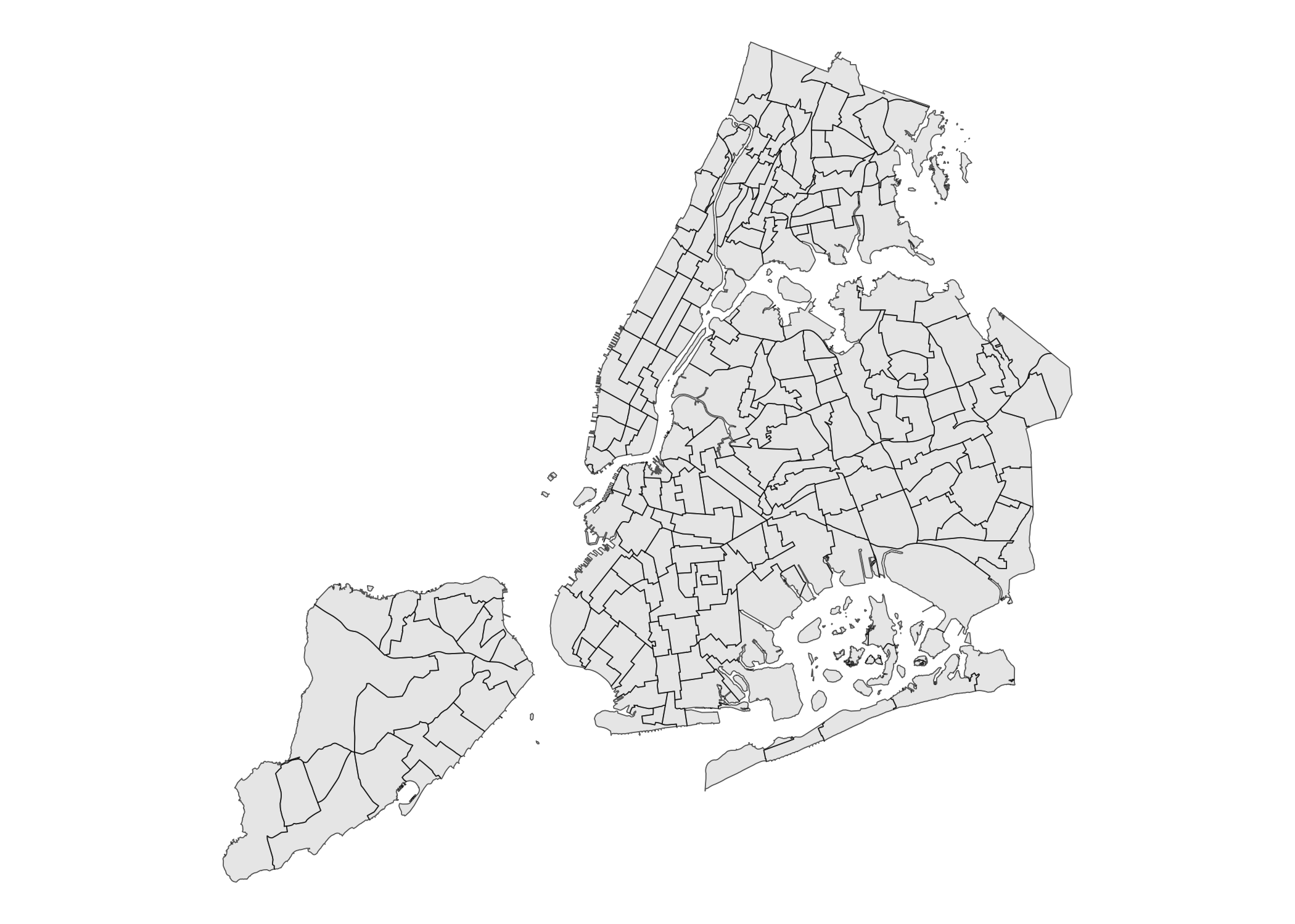
NTA 2020
nyc_nta20_sf
#> Simple feature collection with 262 features and 11 fields
#> Geometry type: MULTIPOLYGON
#> Dimension:     XY
#> Bounding box:  xmin: 913175.1 ymin: 120128.4 xmax: 1067383 ymax: 272844.3
#> Projected CRS: NAD83 / New York Long Island (ftUS)
#> First 10 features:
#>    boro_code boro_name county_fips nta2020                            nta_name
#> 1          3  Brooklyn         047  BK0101                          Greenpoint
#> 2          3  Brooklyn         047  BK0102                        Williamsburg
#> 3          3  Brooklyn         047  BK0103                  South Williamsburg
#> 4          3  Brooklyn         047  BK0104                   East Williamsburg
#> 5          3  Brooklyn         047  BK0201                    Brooklyn Heights
#> 6          3  Brooklyn         047  BK0202 Downtown Brooklyn-DUMBO-Boerum Hill
#> 7          3  Brooklyn         047  BK0203                         Fort Greene
#> 8          3  Brooklyn         047  BK0204                        Clinton Hill
#> 9          3  Brooklyn         047  BK0261                  Brooklyn Navy Yard
#> 10         3  Brooklyn         047  BK0301           Bedford-Stuyvesant (West)
#>    nta_abbrev nta_type cdta2020
#> 1       Grnpt        0     BK01
#> 2    Wllmsbrg        0     BK01
#> 3   SWllmsbrg        0     BK01
#> 4   EWllmsbrg        0     BK01
#> 5       BkHts        0     BK02
#> 6    DwntwnBk        0     BK02
#> 7       FtGrn        0     BK02
#> 8     ClntnHl        0     BK02
#> 9    BkNvyYrd        6     BK02
#> 10    BdSty_W        0     BK03
#>                                                  cdta_name shape_leng
#> 1           BK01 Williamsburg-Greenpoint (CD 1 Equivalent)   28919.56
#> 2           BK01 Williamsburg-Greenpoint (CD 1 Equivalent)   28134.08
#> 3           BK01 Williamsburg-Greenpoint (CD 1 Equivalent)   18250.28
#> 4           BK01 Williamsburg-Greenpoint (CD 1 Equivalent)   43184.80
#> 5  BK02 Downtown Brooklyn-Fort Greene (CD 2 Approximation)   14312.19
#> 6  BK02 Downtown Brooklyn-Fort Greene (CD 2 Approximation)   30589.24
#> 7  BK02 Downtown Brooklyn-Fort Greene (CD 2 Approximation)   23284.59
#> 8  BK02 Downtown Brooklyn-Fort Greene (CD 2 Approximation)   18102.97
#> 9  BK02 Downtown Brooklyn-Fort Greene (CD 2 Approximation)   39415.64
#> 10            BK03 Bedford-Stuyvesant (CD 3 Approximation)   26307.65
#>    shape_area                       geometry
#> 1    35321809 MULTIPOLYGON (((1003060 204...
#> 2    28852853 MULTIPOLYGON (((995851.9 20...
#> 3    15208961 MULTIPOLYGON (((998047.2 19...
#> 4    52267408 MULTIPOLYGON (((1005302 199...
#> 5     9982023 MULTIPOLYGON (((986367.7 19...
#> 6    23731597 MULTIPOLYGON (((990056.4 19...
#> 7    17533714 MULTIPOLYGON (((994554.2 19...
#> 8    14566585 MULTIPOLYGON (((994971 1871...
#> 9    10106807 MULTIPOLYGON (((990092 1964...
#> 10   36906699 MULTIPOLYGON (((999743.6 18...
ggplot(nyc_nta20_sf) +
  geom_sf() +
  theme_void()
Community District Tabulation Areas (CDTAs) 2020
nyc_cdtas_2020_sf
#> Simple feature collection with 71 features and 8 fields
#> Geometry type: MULTIPOLYGON
#> Dimension:     XY
#> Bounding box:  xmin: 913175.1 ymin: 120128.4 xmax: 1067383 ymax: 272844.3
#> Projected CRS: NAD83 / New York Long Island (ftUS)
#> First 10 features:
#>    boro_code boro_name county_fips cdta2020
#> 1          3  Brooklyn         047     BK01
#> 2          3  Brooklyn         047     BK02
#> 3          3  Brooklyn         047     BK03
#> 4          3  Brooklyn         047     BK04
#> 5          3  Brooklyn         047     BK05
#> 6          3  Brooklyn         047     BK06
#> 7          3  Brooklyn         047     BK07
#> 8          3  Brooklyn         047     BK08
#> 9          3  Brooklyn         047     BK09
#> 10         3  Brooklyn         047     BK10
#>                                                  cdta_name cdta_type shape_leng
#> 1           BK01 Williamsburg-Greenpoint (CD 1 Equivalent)         0   65640.60
#> 2  BK02 Downtown Brooklyn-Fort Greene (CD 2 Approximation)         0   65273.41
#> 3             BK03 Bedford-Stuyvesant (CD 3 Approximation)         0   37550.86
#> 4                          BK04 Bushwick (CD 4 Equivalent)         0   36980.75
#> 5    BK05 East New York-Cypress Hills (CD 5 Approximation)         0   78801.48
#> 6     BK06 Park Slope-Carroll Gardens (CD 6 Approximation)         0   77387.93
#> 7    BK07 Sunset Park-Windsor Terrace (CD 7 Approximation)         0   93904.89
#> 8          BK08 Crown Heights (North) (CD 8 Approximation)         0   38333.71
#> 9          BK09 Crown Heights (South) (CD 9 Approximation)         0   32244.39
#> 10      BK10 Bay Ridge-Dyker Heights (CD 10 Approximation)         0   47837.04
#>    shape_area                       geometry
#> 1   131651031 MULTIPOLYGON (((1005302 199...
#> 2    75920725 MULTIPOLYGON (((992763.6 19...
#> 3    78196400 MULTIPOLYGON (((1006979 189...
#> 4    56653765 MULTIPOLYGON (((1012949 187...
#> 5   165460349 MULTIPOLYGON (((1015251 174...
#> 6    86643177 MULTIPOLYGON (((991527.5 18...
#> 7   105547002 MULTIPOLYGON (((989751.2 18...
#> 8    46939593 MULTIPOLYGON (((994971 1871...
#> 9    44093657 MULTIPOLYGON (((1004025 181...
#> 10  109208853 MULTIPOLYGON (((975287.1 17...
ggplot(nyc_cdtas_2020_sf) +
  geom_sf() +
  theme_void()
Police Precincts
nyc_police_precincts_sf
#> Simple feature collection with 78 features and 3 fields
#> Geometry type: MULTIPOLYGON
#> Dimension:     XY
#> Bounding box:  xmin: 913175.1 ymin: 120128.4 xmax: 1067383 ymax: 272844.3
#> Projected CRS: NAD83 / New York Long Island (ftUS)
#> First 10 features:
#>    precinct shape_leng shape_area                       geometry
#> 1         1   80093.49   47284748 MULTIPOLYGON (((972081.8 19...
#> 2         5   18807.08   18094771 MULTIPOLYGON (((987399.2 20...
#> 3         6   27255.99   22143015 MULTIPOLYGON (((981714 2097...
#> 4         7   17287.66   18366632 MULTIPOLYGON (((991608.1 20...
#> 5         9   19772.51   21395386 MULTIPOLYGON (((992119.1 20...
#> 6        10   40227.21   27265501 MULTIPOLYGON (((983866 2172...
#> 7        13   27719.21   29507656 MULTIPOLYGON (((989359.7 21...
#> 8        14   20973.81   20511123 MULTIPOLYGON (((991274 2137...
#> 9        17   26719.68   22268768 MULTIPOLYGON (((994166.3 21...
#> 10       18   41625.18   32250200 MULTIPOLYGON (((985929.4 22...
ggplot(nyc_police_precincts_sf) +
  geom_sf() +
  theme_void()
City Council Districts
nyc_city_council_districts_sf
#> Simple feature collection with 51 features and 3 fields
#> Geometry type: MULTIPOLYGON
#> Dimension:     XY
#> Bounding box:  xmin: 913175.1 ymin: 120128.4 xmax: 1067383 ymax: 272844.3
#> Projected CRS: NAD83 / New York Long Island (ftUS)
#> First 10 features:
#>    coun_dist shape_leng shape_area                       geometry
#> 1         42  220755.07  201334162 MULTIPOLYGON (((1022227 152...
#> 2         45   56967.63  117904762 MULTIPOLYGON (((1005658 176...
#> 3         20   61223.01  144833269 MULTIPOLYGON (((1046345 213...
#> 4         21   87223.84  130912211 MULTIPOLYGON (((1020462 225...
#> 5         22  100202.30  150395658 MULTIPOLYGON (((1016055 223...
#> 6         19  185199.11  334738191 MULTIPOLYGON (((1054980 223...
#> 7         30   75010.43  168734193 MULTIPOLYGON (((1020694 206...
#> 8         29   61867.75  127849354 MULTIPOLYGON (((1035761 193...
#> 9         51  208078.35  657989092 MULTIPOLYGON (((952739.3 13...
#> 10        23   84551.73  311520682 MULTIPOLYGON (((1059187 201...
ggplot(nyc_city_council_districts_sf) +
  geom_sf() +
  theme_void()
Congressional Districts
nyc_congressional_districts_sf
#> Simple feature collection with 13 features and 3 fields
#> Geometry type: MULTIPOLYGON
#> Dimension:     XY
#> Bounding box:  xmin: 913175.1 ymin: 120128.4 xmax: 1067383 ymax: 272844.3
#> Projected CRS: NAD83 / New York Long Island (ftUS)
#> First 10 features:
#>    cong_dist shape_leng shape_area                       geometry
#> 1          3  175356.79  375974759 MULTIPOLYGON (((1054980 223...
#> 2          6  184913.08  727919625 MULTIPOLYGON (((1051683 203...
#> 3         15  172618.76  518928787 MULTIPOLYGON (((1027259 268...
#> 4         16   46530.25   62335247 MULTIPOLYGON (((1032936 263...
#> 5         13  187573.85  310032820 MULTIPOLYGON (((1006029 231...
#> 6         14  645612.38  823458309 MULTIPOLYGON (((1010148 227...
#> 7         11  410304.97 1810248500 MULTIPOLYGON (((970217 1456...
#> 8         12  163510.13  271781952 MULTIPOLYGON (((994681.4 20...
#> 9          9  117420.51  423789158 MULTIPOLYGON (((990773.6 15...
#> 10         8  581728.95  741446257 MULTIPOLYGON (((1022227 152...
ggplot(nyc_congressional_districts_sf) +
  geom_sf() +
  theme_void()
Election Precincts
nyc_election_precincts_sf
#> Simple feature collection with 4264 features and 3 fields
#> Geometry type: MULTIPOLYGON
#> Dimension:     XY
#> Bounding box:  xmin: 913175.1 ymin: 120128.4 xmax: 1067383 ymax: 272844.3
#> Projected CRS: NAD83 / New York Long Island (ftUS)
#> First 10 features:
#>    elect_dist shape_leng shape_area                       geometry
#> 1       23001  24593.971   27791286 MULTIPOLYGON (((1006386 144...
#> 2       23002  15531.630    9753402 MULTIPOLYGON (((1009207 145...
#> 3       23003  41787.652   34529587 MULTIPOLYGON (((1022350 145...
#> 4       23004  13616.939    8166450 MULTIPOLYGON (((1025161 147...
#> 5       23005  10698.548    5077745 MULTIPOLYGON (((1026261 147...
#> 6       23006   9623.945    4381563 MULTIPOLYGON (((1027235 148...
#> 7       23007   8943.399    4008091 MULTIPOLYGON (((1026970 151...
#> 8       23008   9227.254    3228737 MULTIPOLYGON (((1029719 149...
#> 9       23010   9732.741    4133088 MULTIPOLYGON (((1033877 151...
#> 10      23011   7973.345    2931564 MULTIPOLYGON (((1034940 151...
ggplot(nyc_election_precincts_sf) +
  geom_sf() +
  theme_void()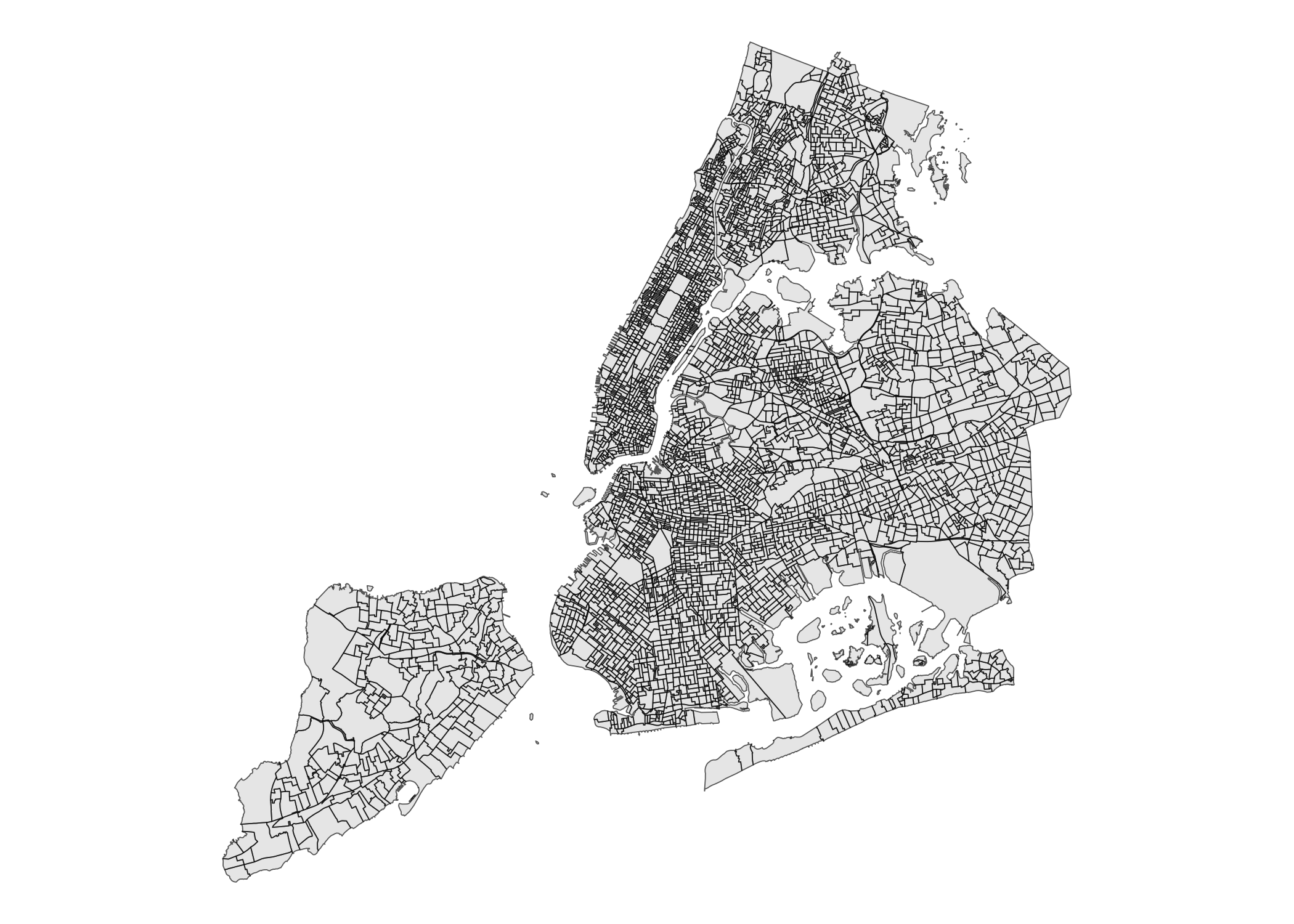
School Districts
nyc_school_districts_sf
#> Simple feature collection with 33 features and 3 fields
#> Geometry type: MULTIPOLYGON
#> Dimension:     XY
#> Bounding box:  xmin: 913175.1 ymin: 120128.4 xmax: 1067383 ymax: 272844.3
#> Projected CRS: NAD83 / New York Long Island (ftUS)
#> First 10 features:
#>    school_dist shape_leng shape_area                       geometry
#> 1            4   52078.41   52615582 MULTIPOLYGON (((1006029 231...
#> 2            9   44448.11   82980177 MULTIPOLYGON (((1002768 241...
#> 3            6   68834.87   96344640 MULTIPOLYGON (((1004602 259...
#> 4            3   51937.18  113406261 MULTIPOLYGON (((996235.5 22...
#> 5            5   44537.03   52531987 MULTIPOLYGON (((1002044 243...
#> 6            2  207557.31  279506456 MULTIPOLYGON (((972081.8 19...
#> 7           30  152555.48  318134015 MULTIPOLYGON (((1024162 215...
#> 8           18  120925.18  175191727 MULTIPOLYGON (((1022227 152...
#> 9           26  131630.79  424301106 MULTIPOLYGON (((1054980 223...
#> 10          29  135111.04  420205351 MULTIPOLYGON (((1056821 204...
ggplot(nyc_school_districts_sf) +
  geom_sf() +
  theme_void()
State Assembly Districts
nyc_state_assembly_districts_sf
#> Simple feature collection with 65 features and 3 fields
#> Geometry type: MULTIPOLYGON
#> Dimension:     XY
#> Bounding box:  xmin: 913175.1 ymin: 120128.4 xmax: 1067383 ymax: 272844.3
#> Projected CRS: NAD83 / New York Long Island (ftUS)
#> First 10 features:
#>    assem_dist shape_leng shape_area                       geometry
#> 1          34   82871.77   98905557 MULTIPOLYGON (((1014868 221...
#> 2          41   69812.24   99108560 MULTIPOLYGON (((1005667 170...
#> 3          42   43463.86   62455425 MULTIPOLYGON (((999844.6 17...
#> 4          48   42806.67   72162537 MULTIPOLYGON (((994847.4 16...
#> 5          49   43217.94   65609484 MULTIPOLYGON (((985297 1722...
#> 6          58   67919.02   93696629 MULTIPOLYGON (((1009969 178...
#> 7          40   44384.76   93268302 MULTIPOLYGON (((1039196 223...
#> 8          66   53046.46   55508067 MULTIPOLYGON (((986404.7 20...
#> 9          67   67713.47   42987449 MULTIPOLYGON (((994296.5 22...
#> 10         75   63372.73   74042940 MULTIPOLYGON (((993379.4 22...
ggplot(nyc_state_assembly_districts_sf) +
  geom_sf() +
  theme_void()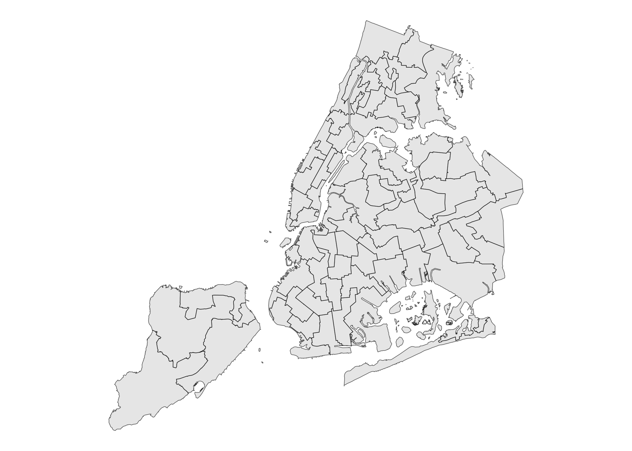
State Senate Districts
nyc_state_senate_districts_sf
#> Simple feature collection with 28 features and 3 fields
#> Geometry type: MULTIPOLYGON
#> Dimension:     XY
#> Bounding box:  xmin: 913175.1 ymin: 120128.4 xmax: 1067383 ymax: 272844.3
#> Projected CRS: NAD83 / New York Long Island (ftUS)
#> First 10 features:
#>    st_sen_dist shape_leng shape_area                       geometry
#> 1           47  116914.55  109448402 MULTIPOLYGON (((996495.9 22...
#> 2           13   64244.10  135422109 MULTIPOLYGON (((1027679 214...
#> 3           12  150399.23  284643976 MULTIPOLYGON (((1015180 218...
#> 4           32   62267.83  129717173 MULTIPOLYGON (((1012340 251...
#> 5           10  573493.67  780597674 MULTIPOLYGON (((1032452 154...
#> 6           29  189962.41  211688668 MULTIPOLYGON (((1012822 229...
#> 7           30   60433.10  115650476 MULTIPOLYGON (((1002388 243...
#> 8           24  283889.38 1287481786 MULTIPOLYGON (((970217 1456...
#> 9           21  114011.07  219693845 MULTIPOLYGON (((1006234 177...
#> 10          28   95721.67  121827370 MULTIPOLYGON (((995988.3 21...
ggplot(nyc_state_senate_districts_sf) +
  geom_sf() +
  theme_void()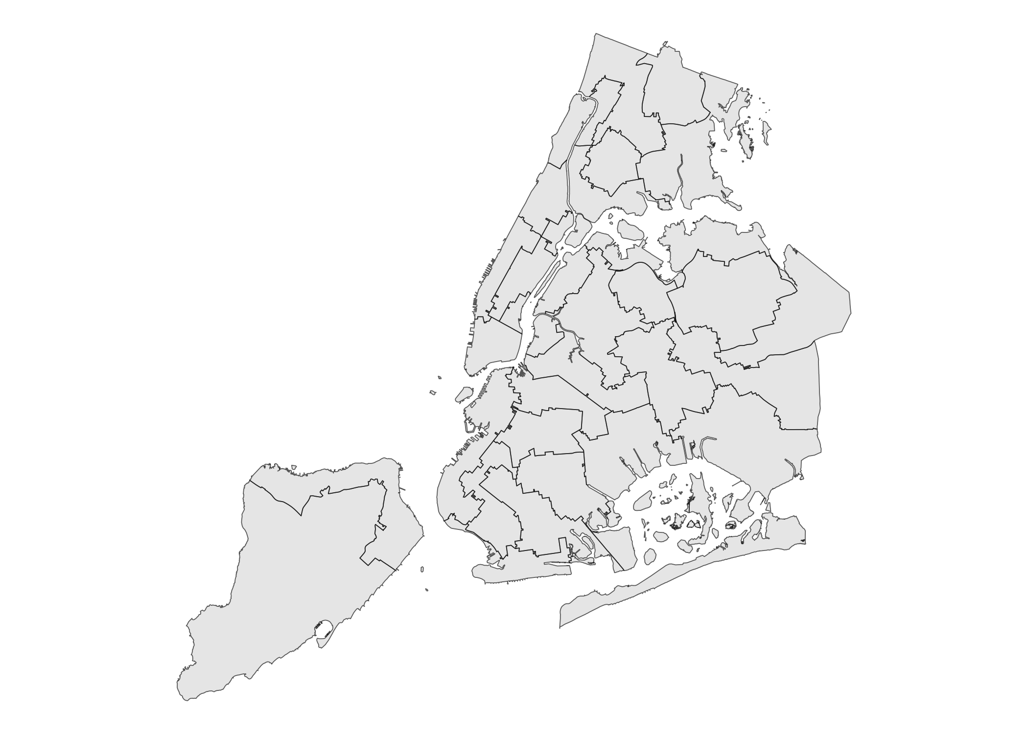
Municipal Court Districts
nyc_municipal_court_districts_sf
#> Simple feature collection with 28 features and 5 fields
#> Geometry type: MULTIPOLYGON
#> Dimension:     XY
#> Bounding box:  xmin: 913175.1 ymin: 120128.4 xmax: 1067383 ymax: 272844.3
#> Projected CRS: NAD83 / New York Long Island (ftUS)
#> First 10 features:
#>    boro_code boro_name muni_court shape_leng shape_area
#> 1          1 Manhattan         05   36454.10   47402234
#> 2          1 Manhattan         10   30266.38   35097563
#> 3          1 Manhattan         03   68414.81   60058562
#> 4          1 Manhattan         06   62229.57   55881633
#> 5          1 Manhattan         04   36843.62   36799497
#> 6          1 Manhattan         01  105921.00   74064085
#> 7          1 Manhattan         09   59416.15   94069751
#> 8          1 Manhattan         08   50608.19   49886363
#> 9          3  Brooklyn         04   92906.38  276207843
#> 10         1 Manhattan         07   94972.60  127656018
#>                          geometry
#> 1  MULTIPOLYGON (((995830.3 23...
#> 2  MULTIPOLYGON (((1002364 240...
#> 3  MULTIPOLYGON (((990013.4 22...
#> 4  MULTIPOLYGON (((1000371 219...
#> 5  MULTIPOLYGON (((995670.1 21...
#> 6  MULTIPOLYGON (((972081.8 19...
#> 7  MULTIPOLYGON (((996625 2305...
#> 8  MULTIPOLYGON (((1006029 231...
#> 9  MULTIPOLYGON (((1019866 171...
#> 10 MULTIPOLYGON (((1004602 259...
ggplot(nyc_municipal_court_districts_sf) +
  geom_sf() +
  theme_void()
Public Use Microdata Areas (PUMAs)
PUMAs 2010
nyc_pumas_2010_sf
#> Simple feature collection with 55 features and 3 fields
#> Geometry type: MULTIPOLYGON
#> Dimension:     XY
#> Bounding box:  xmin: 913175.1 ymin: 120128.4 xmax: 1067383 ymax: 272844.3
#> Projected CRS: NAD83 / New York Long Island (ftUS)
#> First 10 features:
#>    puma shape_leng shape_area                       geometry
#> 1  3701   53220.17   97933067 MULTIPOLYGON (((1012821 271...
#> 2  3702  106172.14  188992061 MULTIPOLYGON (((1041426 260...
#> 3  3703  304545.13  267650498 MULTIPOLYGON (((1042822 243...
#> 4  3704   47983.23  106215095 MULTIPOLYGON (((1031732 252...
#> 5  3705   68717.85  122488328 MULTIPOLYGON (((1020048 256...
#> 6  3706   51814.78   43883136 MULTIPOLYGON (((1017951 260...
#> 7  3707   37374.60   42281080 MULTIPOLYGON (((1014295 253...
#> 8  3708   35002.65   55879734 MULTIPOLYGON (((1005292 247...
#> 9  3709   73295.40  124116532 MULTIPOLYGON (((1029456 237...
#> 10 3710   90061.99  137759772 MULTIPOLYGON (((1012822 229...
ggplot(nyc_pumas_2010_sf) +
  geom_sf() +
  theme_void()
PUMAs 2020
nyc_pumas_2020_sf
#> Simple feature collection with 55 features and 3 fields
#> Geometry type: MULTIPOLYGON
#> Dimension:     XY
#> Bounding box:  xmin: 913175.1 ymin: 120128.4 xmax: 1067383 ymax: 272844.3
#> Projected CRS: NAD83 / New York Long Island (ftUS)
#> First 10 features:
#>    puma shape_leng shape_area                       geometry
#> 1  4103   35298.18   46999512 MULTIPOLYGON (((989137.1 19...
#> 2  4104   65054.20   48054068 MULTIPOLYGON (((985958.7 22...
#> 3  4107   47585.32   92720945 MULTIPOLYGON (((995422.2 23...
#> 4  4108   54354.66   55211354 MULTIPOLYGON (((995988.3 21...
#> 5  4109   34907.04   42641157 MULTIPOLYGON (((1000815 241...
#> 6  4110   36202.62   38219322 MULTIPOLYGON (((1002388 243...
#> 7  4111   61538.17   66239796 MULTIPOLYGON (((1006029 231...
#> 8  4112   62521.40   81279102 MULTIPOLYGON (((1004602 259...
#> 9  4121  120223.29   82729002 MULTIPOLYGON (((981219.1 18...
#> 10 4165   49051.32   82533592 MULTIPOLYGON (((994681.4 20...
ggplot(nyc_pumas_2020_sf) +
  geom_sf() +
  theme_void()
Fire Companies
nyc_fire_companies_sf
#> Simple feature collection with 348 features and 6 fields
#> Geometry type: MULTIPOLYGON
#> Dimension:     XY
#> Bounding box:  xmin: 913175.1 ymin: 120128.4 xmax: 1067383 ymax: 272844.3
#> Projected CRS: NAD83 / New York Long Island (ftUS)
#> First 10 features:
#>    fire_co_type fire_co_num fire_bn fire_div shape_leng shape_area
#> 1             E          14       6        1   8598.392    3802284
#> 2             E         227      44       15  12410.321    5331327
#> 3             E         231      44       15  17219.986   14515553
#> 4             E         246      43        8  18119.281   20391773
#> 5             E         257      58       15  21645.823   23816862
#> 6             E         283      58       15  13284.654    7410540
#> 7             E         310      58       15  23115.730   27246701
#> 8             E         325      49       14  15109.566    8899265
#> 9             E         332      44       15  16614.469   12913114
#> 10            E          65       8        3   8863.043    4437859
#>                          geometry
#> 1  MULTIPOLYGON (((988342.4 20...
#> 2  MULTIPOLYGON (((1007855 180...
#> 3  MULTIPOLYGON (((1012724 180...
#> 4  MULTIPOLYGON (((995421 1532...
#> 5  MULTIPOLYGON (((1012980 179...
#> 6  MULTIPOLYGON (((1007465 177...
#> 7  MULTIPOLYGON (((1006966 176...
#> 8  MULTIPOLYGON (((1008843 210...
#> 9  MULTIPOLYGON (((1017787 189...
#> 10 MULTIPOLYGON (((989106.6 21...
ggplot(nyc_fire_companies_sf) +
  geom_sf() +
  theme_void()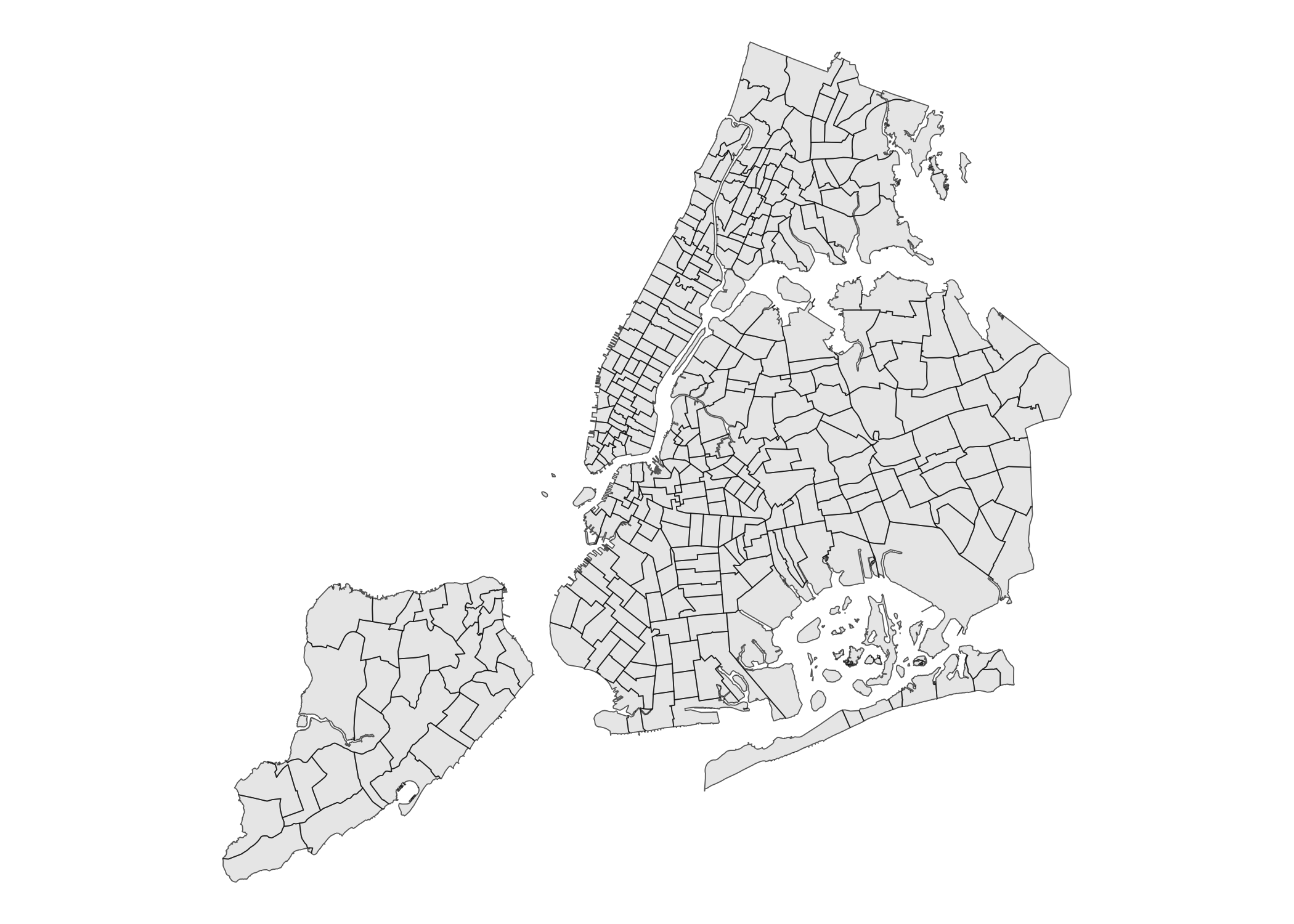
Census Tracts
Census Tracts 2000
nyc_census_tracts_2000_sf
#> Simple feature collection with 2216 features and 11 fields
#> Geometry type: MULTIPOLYGON
#> Dimension:     XY
#> Bounding box:  xmin: 913175.1 ymin: 120121.9 xmax: 1067383 ymax: 272844.3
#> Projected CRS: NAD83 / New York Long Island (ftUS)
#> First 10 features:
#>    ct_label boro_code boro_name ct2000 boro_ct2000 cd_eligibil nta_code
#> 1        98         1 Manhattan 009800     1009800           I     MN19
#> 2       190         1 Manhattan 019000     1019000           E     MN11
#> 3       206         1 Manhattan 020600     1020600           E     MN03
#> 4    231.02         1 Manhattan 023102     1023102           E     MN03
#> 5       249         1 Manhattan 024900     1024900           E     MN36
#> 6       263         1 Manhattan 026300     1026300           E     MN36
#> 7       269         1 Manhattan 026900     1026900           E     MN35
#> 8       277         1 Manhattan 027700     1027700           E     MN35
#> 9       102         1 Manhattan 010200     1010200           I     MN17
#> 10      104         1 Manhattan 010400     1010400           I     MN17
#>                             ntan_ame puma shape_leng shape_area
#> 1            Turtle Bay-East Midtown 3808   5534.200  1906016.4
#> 2               Central Harlem South 3803   4231.827  1117371.7
#> 3  Central Harlem North-Polo Grounds 3803   5176.873  1602693.8
#> 4  Central Harlem North-Polo Grounds 3803   3267.741   413467.6
#> 5           Washington Heights South 3801   3927.822   652856.5
#> 6           Washington Heights South 3801   5730.542  1691892.0
#> 7           Washington Heights North 3801   6017.037  1889655.8
#> 8           Washington Heights North 3801   5903.153  1760156.1
#> 9              Midtown-Midtown South 3807   5687.802  1860992.7
#> 10             Midtown-Midtown South 3807   5693.036  1864600.4
#>                          geometry
#> 1  MULTIPOLYGON (((994133.5 21...
#> 2  MULTIPOLYGON (((999462.8 23...
#> 3  MULTIPOLYGON (((1002020 234...
#> 4  MULTIPOLYGON (((1000966 240...
#> 5  MULTIPOLYGON (((1001768 244...
#> 6  MULTIPOLYGON (((1002443 248...
#> 7  MULTIPOLYGON (((1004253 249...
#> 8  MULTIPOLYGON (((1004253 249...
#> 9  MULTIPOLYGON (((992216.5 21...
#> 10 MULTIPOLYGON (((991325.9 21...
ggplot(nyc_census_tracts_2000_sf) +
  geom_sf() +
  theme_void()
Census Tracts 2010
nyc_census_tracts_2010_sf
#> Simple feature collection with 2165 features and 11 fields
#> Geometry type: MULTIPOLYGON
#> Dimension:     XY
#> Bounding box:  xmin: 913175.1 ymin: 120128.4 xmax: 1067383 ymax: 272844.3
#> Projected CRS: NAD83 / New York Long Island (ftUS)
#> First 10 features:
#>    ct_label boro_code     boro_name ct2010 boro_ct2010 cd_eligibil nta_code
#> 1         9         5 Staten Island 000900     5000900           E     SI22
#> 2       102         1     Manhattan 010200     1010200           I     MN17
#> 3       104         1     Manhattan 010400     1010400           I     MN17
#> 4       113         1     Manhattan 011300     1011300           I     MN17
#> 5       130         1     Manhattan 013000     1013000           I     MN40
#> 6       184         1     Manhattan 018400     1018400           E     MN34
#> 7       206         1     Manhattan 020600     1020600           E     MN03
#> 8       249         1     Manhattan 024900     1024900           I     MN36
#> 9       269         1     Manhattan 026900     1026900           E     MN35
#> 10     5.01         3      Brooklyn 000501     3000501           I     BK09
#>                                     nta_name puma shape_leng shape_area
#> 1  West New Brighton-New Brighton-St. George 3903   7729.017  2497009.7
#> 2                      Midtown-Midtown South 3807   5687.802  1860992.7
#> 3                      Midtown-Midtown South 3807   5693.036  1864600.4
#> 4                      Midtown-Midtown South 3807   5699.861  1890907.3
#> 5              Upper East Side-Carnegie Hill 3805   5807.973  1918144.6
#> 6                          East Harlem North 3804   5771.874  1903568.4
#> 7          Central Harlem North-Polo Grounds 3803   5176.873  1602693.8
#> 8                   Washington Heights South 3801   3927.822   652856.3
#> 9                   Washington Heights North 3801   6017.037  1889655.6
#> 10              Brooklyn Heights-Cobble Hill 4004   4828.170   901507.1
#>                          geometry
#> 1  MULTIPOLYGON (((962269.1 17...
#> 2  MULTIPOLYGON (((992216.5 21...
#> 3  MULTIPOLYGON (((991325.9 21...
#> 4  MULTIPOLYGON (((988650.3 21...
#> 5  MULTIPOLYGON (((994920.1 22...
#> 6  MULTIPOLYGON (((1000359 231...
#> 7  MULTIPOLYGON (((1002020 234...
#> 8  MULTIPOLYGON (((1001768 244...
#> 9  MULTIPOLYGON (((1004253 249...
#> 10 MULTIPOLYGON (((986186 1933...
ggplot(nyc_census_tracts_2010_sf) +
  geom_sf() +
  theme_void()
Census Tracts 2020
nyc_census_tracts_2020_sf
#> Simple feature collection with 2325 features and 14 fields
#> Geometry type: MULTIPOLYGON
#> Dimension:     XY
#> Bounding box:  xmin: 913175.1 ymin: 120128.4 xmax: 1067383 ymax: 272844.3
#> Projected CRS: NAD83 / New York Long Island (ftUS)
#> First 10 features:
#>    ct_label boro_code boro_name ct2020 boro_ct2020 cd_eligibil
#> 1         1         1 Manhattan 000100     1000100           I
#> 2     14.01         1 Manhattan 001401     1001401           I
#> 3     14.02         1 Manhattan 001402     1001402           E
#> 4        18         1 Manhattan 001800     1001800           I
#> 5     22.01         1 Manhattan 002201     1002201           E
#> 6     26.02         1 Manhattan 002602     1002602           E
#> 7        28         1 Manhattan 002800     1002800           E
#> 8        34         1 Manhattan 003400     1003400           I
#> 9     36.01         1 Manhattan 003601     1003601           E
#> 10    36.02         1 Manhattan 003602     1003602           I
#>                                                    nta_name nta2020 cdta2020
#> 1  The Battery-Governors Island-Ellis Island-Liberty Island  MN0191     MN01
#> 2                                           Lower East Side  MN0302     MN03
#> 3                                           Lower East Side  MN0302     MN03
#> 4                                           Lower East Side  MN0302     MN03
#> 5                                           Lower East Side  MN0302     MN03
#> 6                                              East Village  MN0303     MN03
#> 7                                              East Village  MN0303     MN03
#> 8                                              East Village  MN0303     MN03
#> 9                                           Lower East Side  MN0302     MN03
#> 10                                             East Village  MN0303     MN03
#>                                             cdtaname       geoid puma
#> 1  MN01 Financial District-Tribeca (CD 1 Equivalent) 36061000100 4121
#> 2   MN03 Lower East Side-Chinatown (CD 3 Equivalent) 36061001401 4103
#> 3   MN03 Lower East Side-Chinatown (CD 3 Equivalent) 36061001402 4103
#> 4   MN03 Lower East Side-Chinatown (CD 3 Equivalent) 36061001800 4103
#> 5   MN03 Lower East Side-Chinatown (CD 3 Equivalent) 36061002201 4103
#> 6   MN03 Lower East Side-Chinatown (CD 3 Equivalent) 36061002602 4103
#> 7   MN03 Lower East Side-Chinatown (CD 3 Equivalent) 36061002800 4103
#> 8   MN03 Lower East Side-Chinatown (CD 3 Equivalent) 36061003400 4103
#> 9   MN03 Lower East Side-Chinatown (CD 3 Equivalent) 36061003601 4103
#> 10  MN03 Lower East Side-Chinatown (CD 3 Equivalent) 36061003602 4103
#>    shape_leng shape_area                       geometry
#> 1   10833.044  1843004.5 MULTIPOLYGON (((972081.8 19...
#> 2    5075.332  1006116.6 MULTIPOLYGON (((987475 2002...
#> 3    4459.156  1226206.2 MULTIPOLYGON (((988387.7 20...
#> 4    6391.921  2399276.9 MULTIPOLYGON (((987062.3 20...
#> 5    5779.063  1740173.9 MULTIPOLYGON (((990139.8 20...
#> 6    4491.203  1114857.1 MULTIPOLYGON (((991015.1 20...
#> 7    5627.555  1973678.5 MULTIPOLYGON (((991650.9 20...
#> 8    5503.307  1718451.6 MULTIPOLYGON (((990340 2050...
#> 9    4201.295  1082296.2 MULTIPOLYGON (((987399.2 20...
#> 10   4076.250   961070.5 MULTIPOLYGON (((987717.2 20...
ggplot(nyc_census_tracts_2020_sf) +
  geom_sf() +
  theme_void()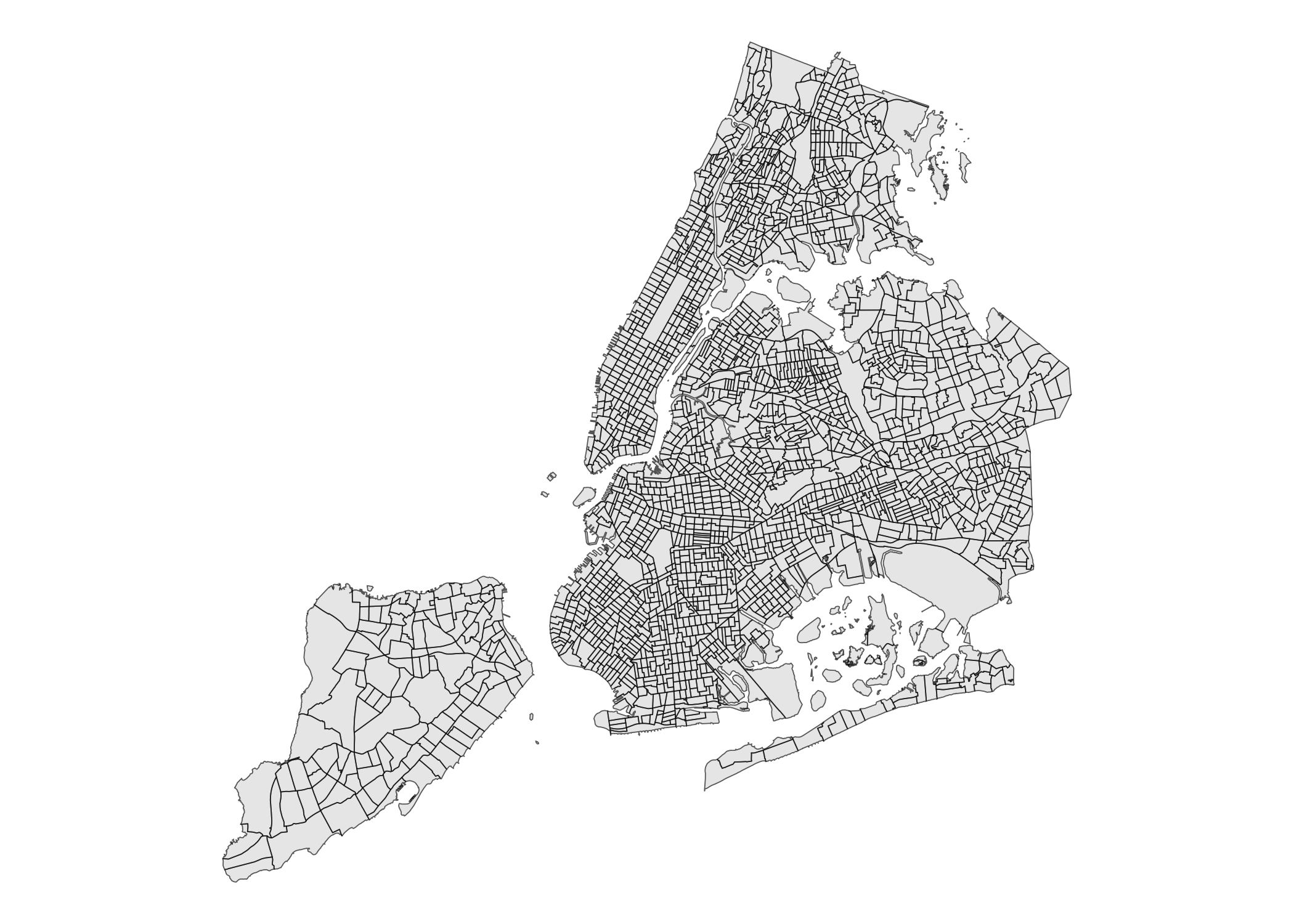
Census Blocks
Census Blocks 2000
nyc_census_blocks_2000_sf
#> Simple feature collection with 36721 features and 7 fields
#> Geometry type: MULTIPOLYGON
#> Dimension:     XY
#> Bounding box:  xmin: 913175.1 ymin: 120121.9 xmax: 1067383 ymax: 272844.3
#> Projected CRS: NAD83 / New York Long Island (ftUS)
#> First 10 features:
#>      bctcb2000 cb2000 boro_code boro_name ct2000 shape_leng  shape_area
#> 1  10001001000   1000         1 Manhattan 000100  6627.8582 1204254.996
#> 2  10002011000   1000         1 Manhattan 000201  1565.8519  127283.120
#> 3  10002021000   1000         1 Manhattan 000202  1187.8839   57115.937
#> 4  10005001000   1000         1 Manhattan 000500 23821.6173  528518.739
#> 5  10006001000   1000         1 Manhattan 000600  1352.3708  106094.568
#> 6  10007001000   1000         1 Manhattan 000700   930.7537   50021.645
#> 7  10008001000   1000         1 Manhattan 000800   530.0671   13818.523
#> 8  10009001000   1000         1 Manhattan 000900  1596.6596  147868.271
#> 9  10010011000   1000         1 Manhattan 001001   714.1657   29763.941
#> 10 10010021000   1000         1 Manhattan 001002   188.6376    2305.824
#>                          geometry
#> 1  MULTIPOLYGON (((973172.7 19...
#> 2  MULTIPOLYGON (((988340.9 19...
#> 3  MULTIPOLYGON (((989805 1993...
#> 4  MULTIPOLYGON (((979605.8 19...
#> 5  MULTIPOLYGON (((987836.9 19...
#> 6  MULTIPOLYGON (((982933.4 19...
#> 7  MULTIPOLYGON (((986338 1993...
#> 8  MULTIPOLYGON (((981069.3 19...
#> 9  MULTIPOLYGON (((990732.4 19...
#> 10 MULTIPOLYGON (((991201.3 20...
ggplot(nyc_census_blocks_2000_sf) +
  geom_sf() +
  theme_void()
Census Blocks 2010
nyc_census_blocks_2010_sf
#> Simple feature collection with 38797 features and 7 fields
#> Geometry type: MULTIPOLYGON
#> Dimension:     XY
#> Bounding box:  xmin: 913175.1 ymin: 120128.4 xmax: 1067383 ymax: 272844.3
#> Projected CRS: NAD83 / New York Long Island (ftUS)
#> First 10 features:
#>    cb2010 boro_code     boro_name ct2010   bctcb2010 shape_leng shape_area
#> 1    1000         5 Staten Island 000900 50009001000   2508.948  244589.57
#> 2    1000         5 Staten Island 002001 50020011000   1345.886  111006.26
#> 3    1000         5 Staten Island 002700 50027001000   1703.381  150406.77
#> 4    1000         5 Staten Island 004000 50040001000   1511.174  141296.56
#> 5    1000         5 Staten Island 006400 50064001000   1978.244  200784.98
#> 6    1000         5 Staten Island 007400 50074001000   1540.876  139084.02
#> 7    1000         5 Staten Island 007500 50075001000   1412.643  123560.55
#> 8    1000         5 Staten Island 007700 50077001000   2421.037  205770.94
#> 9    1000         5 Staten Island 011202 50112021000   1233.682   92737.75
#> 10   1000         5 Staten Island 011401 50114011000   1094.120   66684.10
#>                          geometry
#> 1  MULTIPOLYGON (((962269.1 17...
#> 2  MULTIPOLYGON (((964642.3 16...
#> 3  MULTIPOLYGON (((963363.1 16...
#> 4  MULTIPOLYGON (((960070 1619...
#> 5  MULTIPOLYGON (((963023.9 15...
#> 6  MULTIPOLYGON (((965950.6 15...
#> 7  MULTIPOLYGON (((960467.3 17...
#> 8  MULTIPOLYGON (((960079.6 17...
#> 9  MULTIPOLYGON (((956638.1 15...
#> 10 MULTIPOLYGON (((957255.3 15...
ggplot(nyc_census_blocks_2010_sf) +
  geom_sf() +
  theme_void()
Census Blocks 2020
nyc_census_blocks_2020_sf
#> Simple feature collection with 37588 features and 8 fields
#> Geometry type: MULTIPOLYGON
#> Dimension:     XY
#> Bounding box:  xmin: 913175.1 ymin: 120128.4 xmax: 1067383 ymax: 272844.3
#> Projected CRS: NAD83 / New York Long Island (ftUS)
#> First 10 features:
#>    cb2020 boro_code boro_name ct2020   bctcb2020           geoid shape_leng
#> 1    1000         1 Manhattan 000100 10001001000 360610001001000  6437.8537
#> 2    1001         1 Manhattan 000100 10001001001 360610001001001  4395.1902
#> 3    1000         1 Manhattan 000201 10002011000 360610002011000  1569.3848
#> 4    1001         1 Manhattan 000201 10002011001 360610002011001  1594.2629
#> 5    2000         1 Manhattan 000201 10002012000 360610002012000  2055.2960
#> 6    1000         1 Manhattan 000202 10002021000 360610002021000  1187.8841
#> 7    1003         1 Manhattan 000202 10002021003 360610002021003   732.8414
#> 8    1004         1 Manhattan 000202 10002021004 360610002021004  1158.4129
#> 9    2000         1 Manhattan 000202 10002022000 360610002022000  2178.7774
#> 10   2001         1 Manhattan 000202 10002022001 360610002022001  2113.9173
#>    shape_area                       geometry
#> 1  1202838.17 MULTIPOLYGON (((973172.7 19...
#> 2   640166.35 MULTIPOLYGON (((972081.8 19...
#> 3   129276.33 MULTIPOLYGON (((988376.7 19...
#> 4   139360.45 MULTIPOLYGON (((988392.4 19...
#> 5   263308.44 MULTIPOLYGON (((988422.2 19...
#> 6    57115.98 MULTIPOLYGON (((989805 1993...
#> 7    26020.57 MULTIPOLYGON (((988376.7 19...
#> 8    82791.72 MULTIPOLYGON (((988718.2 19...
#> 9   157313.54 MULTIPOLYGON (((989275.1 19...
#> 10  173815.26 MULTIPOLYGON (((988874.9 19...
ggplot(nyc_census_blocks_2020_sf) +
  geom_sf() +
  theme_void()
Atomic Polygons
nyc_atomic_polygons_sf
#> Simple feature collection with 69690 features and 29 fields
#> Geometry type: MULTIPOLYGON
#> Dimension:     XY
#> Bounding box:  xmin: 912287.1 ymin: 113279.3 xmax: 1067383 ymax: 273617.8
#> Projected CRS: NAD83 / New York Long Island (ftUS)
#> First 10 features:
#>    borough censusbloc censusbl_1 censustrac censusbl_2 censusbl_3 censustr_1
#> 1        5       4023       <NA>     024400       1020       <NA>     024401
#> 2        5       4030       <NA>     024400       2004       <NA>     024401
#> 3        5       2002          B     024400       1005       <NA>     024402
#> 4        5       4031       <NA>     024400       2005       <NA>     024401
#> 5        5       4015       <NA>     024400       1018       <NA>     024401
#> 6        5       4014       <NA>     024400       1011       <NA>     024401
#> 7        5       3033       <NA>     024400       2019       <NA>     024402
#> 8        5       3035       <NA>     024400       2020       <NA>     024402
#> 9        5       3031       <NA>     024400       2016       <NA>     024402
#> 10       5       3029       <NA>     024400       2034       <NA>     024402
#>    censustr_2 admin_fire water_flag assemdist electdist schooldist commdist
#> 1      024400      E 151          2        62       002         31      503
#> 2      024400      E 151          2        62       006         31      503
#> 3      024400      E 151          2        62       004         31      503
#> 4      024400      E 151          2        62       006         31      503
#> 5      024400      E 151          2        62       002         31      503
#> 6      024400      E 151          2        62       002         31      503
#> 7      024400      E 151          2        62       001         31      503
#> 8      024400      E 151          2        62       001         31      503
#> 9      024400      E 151          2        62       001         31      503
#> 10     024400      E 151          2        62       001         31      503
#>    sb1_volume sb1_page sb2_volume sb2_page sb3_volume sb3_page   atomicid
#> 1          05      533       <NA>     <NA>       <NA>     <NA> 5024401430
#> 2          05      533       <NA>     <NA>       <NA>     <NA> 5024401439
#> 3          05      530         05      529       <NA>     <NA> 5024402223
#> 4          05      533       <NA>     <NA>       <NA>     <NA> 5024401441
#> 5          05      532       <NA>     <NA>       <NA>     <NA> 5024401440
#> 6          05      532       <NA>     <NA>       <NA>     <NA> 5024401465
#> 7          00      000       <NA>     <NA>       <NA>     <NA> 5024402341
#> 8          00      000       <NA>     <NA>       <NA>     <NA> 5024402308
#> 9          00      000       <NA>     <NA>       <NA>     <NA> 5024402339
#> 10         05      534       <NA>     <NA>       <NA>     <NA> 5024402337
#>    atomic_num hurricane censustr_3 censusbl_4 censusbl_5 commercial shape_leng
#> 1        <NA>         X     024401       1007       <NA>        SI1  2424.5604
#> 2        <NA>         X     024401       2010       <NA>        SI1  1722.9312
#> 3        <NA>         6     024402       1004       <NA>        SI1   770.0857
#> 4        <NA>         X     024401       2011       <NA>        SI1  1697.9085
#> 5        <NA>         X     024401       1021       <NA>        SI1  1243.1069
#> 6        <NA>         X     024401       1018       <NA>        SI1  1259.2088
#> 7        <NA>         1     024402       2010       <NA>        SI1  1866.8869
#> 8        <NA>         1     024402       2010       <NA>        SI1  1018.7129
#> 9        <NA>         1     024402       2010       <NA>        SI1  1556.3802
#> 10       <NA>         1     024402       2010       <NA>        SI1  1588.9853
#>    shape_area                       geometry
#> 1   244110.62 MULTIPOLYGON (((916060.7 12...
#> 2   177042.35 MULTIPOLYGON (((917670.2 12...
#> 3    33790.84 MULTIPOLYGON (((920007.2 12...
#> 4   171623.34 MULTIPOLYGON (((918015.6 12...
#> 5    78855.83 MULTIPOLYGON (((914247.2 12...
#> 6    92975.91 MULTIPOLYGON (((913894.6 12...
#> 7   180710.25 MULTIPOLYGON (((915716 1203...
#> 8    64847.42 MULTIPOLYGON (((915016.6 12...
#> 9   133972.42 MULTIPOLYGON (((916170.7 12...
#> 10  136178.82 MULTIPOLYGON (((916661.1 12...
ggplot(nyc_atomic_polygons_sf) +
  geom_sf() +
  theme_void()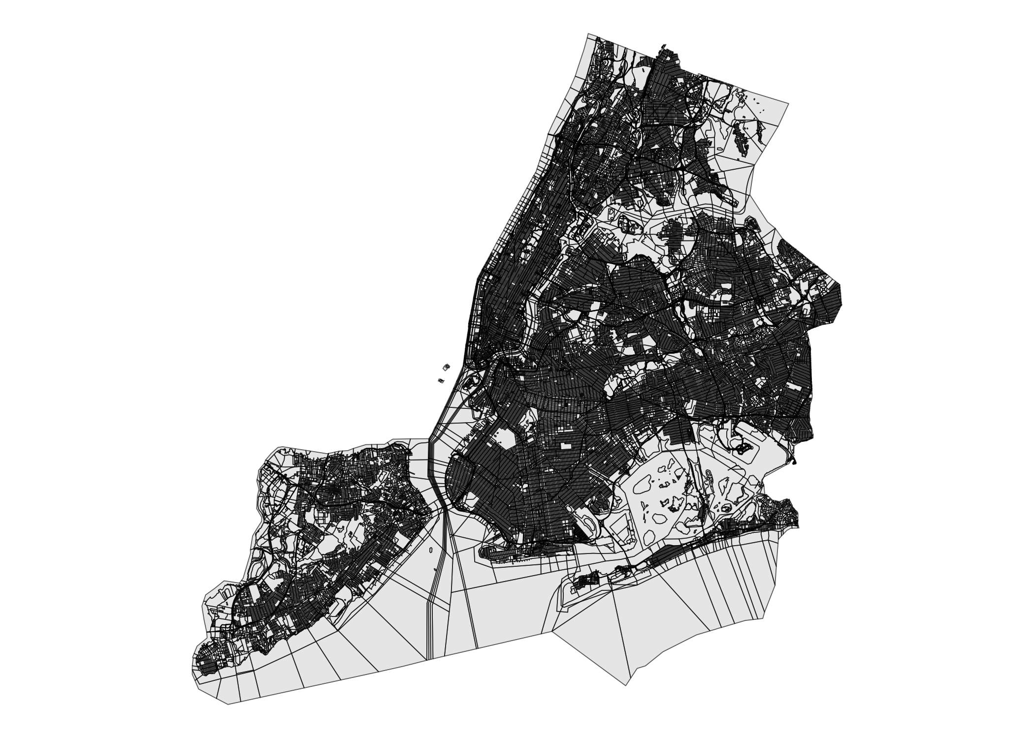
Census Tract Population Proportions 2010-2020
nyc_ct_pop_proportion_2010_2020_df
#> # A tibble: 2,416 × 8
#>    boro_code county_fips boro_name bct2020 fipsct2020 bct2010 fipsct2010
#>        <dbl> <chr>       <chr>     <chr>   <chr>      <chr>   <chr>
#>  1         2 005         Bronx     2000100 005000100  2000100 005000100
#>  2         2 005         Bronx     2000200 005000200  2000200 005000200
#>  3         2 005         Bronx     2000400 005000400  2000400 005000400
#>  4         2 005         Bronx     2001600 005001600  2001600 005001600
#>  5         2 005         Bronx     2001901 005001901  2001900 005001900
#>  6         2 005         Bronx     2001902 005001902  2001900 005001900
#>  7         2 005         Bronx     2001903 005001903  2001900 005001900
#>  8         2 005         Bronx     2001904 005001904  2001900 005001900
#>  9         2 005         Bronx     2002001 005002001  2002000 005002000
#> 10         2 005         Bronx     2002002 005002002  2002000 005002000
#> # ℹ 2,406 more rows
#> # ℹ 1 more variable: prptn10t20 <dbl>
Census Block Relationships 2020
nyc_census_block_relationships_2020_df
#> # A tibble: 37,984 × 17
#>    geoid   county_fips boro_code boro_name bctcb2020 cb2020 cb_label boro_ct2020
#>    <chr>   <chr>           <dbl> <chr>     <chr>      <dbl> <chr>    <chr>
#>  1 360811… 081                 4 Queens    41085001…   1000 Block 1… 4108500
#>  2 360811… 081                 4 Queens    41085001…   1001 Block 1… 4108500
#>  3 360811… 081                 4 Queens    41085001…   1002 Block 1… 4108500
#>  4 360811… 081                 4 Queens    41085001…   1003 Block 1… 4108500
#>  5 360811… 081                 4 Queens    41085001…   1004 Block 1… 4108500
#>  6 360811… 081                 4 Queens    41085001…   1005 Block 1… 4108500
#>  7 360811… 081                 4 Queens    41085001…   1006 Block 1… 4108500
#>  8 360811… 081                 4 Queens    41085001…   1007 Block 1… 4108500
#>  9 360811… 081                 4 Queens    41085001…   1008 Block 1… 4108500
#> 10 360811… 081                 4 Queens    41085001…   1009 Block 1… 4108500
#> # ℹ 37,974 more rows
#> # ℹ 9 more variables: ct2020 <chr>, ct_label <chr>, nta_code <chr>,
#> #   nta_type <dbl>, nta_name <chr>, nta_abbrev <chr>, cdta_code <chr>,
#> #   cdta_type <chr>, cdta_name <chr>
Census Tract to City Council District Relationships 2023
nyc_ct_ccd_relationships_2023_df
#> # A tibble: 2,327 × 8
#>    geoid     county_fips boro_code boro_name boro_ct2020 ct2020 ct_label ccd2023
#>    <chr>     <chr>           <dbl> <chr>           <dbl> <chr>  <chr>    <chr>
#>  1 36005001… 005                 2 Bronx         2001901 001901 19.01    08
#>  2 36005001… 005                 2 Bronx         2001902 001902 19.02    08
#>  3 36005001… 005                 2 Bronx         2001903 001903 19.03    08
#>  4 36005002… 005                 2 Bronx         2002300 002300 23       08
#>  5 36005002… 005                 2 Bronx         2002500 002500 25       08
#>  6 36005002… 005                 2 Bronx         2002701 002701 27.01    08
#>  7 36005002… 005                 2 Bronx         2002702 002702 27.02    08
#>  8 36005003… 005                 2 Bronx         2003100 003100 31       08
#>  9 36005003… 005                 2 Bronx         2003300 003300 33       08
#> 10 36005003… 005                 2 Bronx         2003500 003500 35       08
#> # ℹ 2,317 more rows
Census Tract Relationships 2020
nyc_census_tract_relationships_2020_df
#> # A tibble: 2,327 × 14
#>    geoid    county_fips boro_code boro_name boro_ct2020 ct2020 ct_label nta_code
#>    <chr>    <chr>           <dbl> <chr>     <chr>       <chr>  <chr>    <chr>
#>  1 3600500… 005                 2 Bronx     2001901     001901 19.01    BX0101
#>  2 3600500… 005                 2 Bronx     2001902     001902 19.02    BX0101
#>  3 3600500… 005                 2 Bronx     2001903     001903 19.03    BX0101
#>  4 3600500… 005                 2 Bronx     2002300     002300 23       BX0101
#>  5 3600500… 005                 2 Bronx     2002500     002500 25       BX0101
#>  6 3600500… 005                 2 Bronx     2002701     002701 27.01    BX0101
#>  7 3600500… 005                 2 Bronx     2002702     002702 27.02    BX0101
#>  8 3600500… 005                 2 Bronx     2003100     003100 31       BX0101
#>  9 3600500… 005                 2 Bronx     2003300     003300 33       BX0101
#> 10 3600500… 005                 2 Bronx     2003500     003500 35       BX0101
#> # ℹ 2,317 more rows
#> # ℹ 6 more variables: nta_type <dbl>, nta_name <chr>, nta_abbrev <chr>,
#> #   cdta_code <chr>, cdta_type <chr>, cdta_name <chr>
Shoreline with Adjacent Areas
nyc_shoclip_sf
#> Simple feature collection with 7426 features and 15 fields (with 222 geometries empty)
#> Geometry type: GEOMETRY
#> Dimension:     XY
#> Bounding box:  xmin: 913175.1 ymin: 120128.4 xmax: 1067338 ymax: 272744.1
#> Projected CRS: NAD83 / New York Long Island (ftUS)
#> First 10 features:
#>    SOURCE_ID SRC_DATE HOR_ACC  INFORM                     ATTRIBUTE VER_DATE
#> 1       <NA> 19991015     2.5    <NA> Man-made.Bulkhead Or Sea Wall     <NA>
#> 2       <NA> 19991015     2.5 Culvert Man-made.Bulkhead Or Sea Wall     <NA>
#> 3       <NA> 19991015     2.5 Culvert Man-made.Bulkhead Or Sea Wall     <NA>
#> 4       <NA> 20140601     1.7    <NA>                 Man-made.Ramp     <NA>
#> 5       <NA> 20140607     0.6    <NA> Man-made.Bulkhead Or Sea Wall     <NA>
#> 6       <NA> 20140607     0.6 Culvert Man-made.Bulkhead Or Sea Wall     <NA>
#> 7       <NA> 20140607     0.6 Culvert Man-made.Bulkhead Or Sea Wall     <NA>
#> 8       <NA> 20140607     1.1    <NA>       Natural.Mean High Water     <NA>
#> 9       <NA> 20201104      18    <NA> Man-made.Bulkhead Or Sea Wall     <NA>
#> 10      <NA> 20201104      18    <NA> Man-made.Bulkhead Or Sea Wall     <NA>
#>    SRC_RESOLU         DATA_SOURC EX_METH EXT_METH DAT_SET_CR SRC_CITA
#> 1           0 Aerial Photography  Stereo   Stereo       NOAA     <NA>
#> 2           0 Aerial Photography  Stereo   Stereo       NOAA     <NA>
#> 3           0 Aerial Photography  Stereo   Stereo       NOAA     <NA>
#> 4           0  Satellite Imagery    Mono     Mono       NOAA     <NA>
#> 5           0 Aerial Photography  Stereo   Stereo       NOAA     <NA>
#> 6           0 Aerial Photography  Stereo   Stereo       NOAA     <NA>
#> 7           0 Aerial Photography  Stereo   Stereo       NOAA     <NA>
#> 8           0  Satellite Imagery    Mono     Mono       NOAA     <NA>
#> 9           0  Satellite Imagery    Mono     Mono       NOAA     <NA>
#> 10          0  Satellite Imagery    Mono     Mono       NOAA     <NA>
#>    FIPS_ALPHA     NOAA_Regio   Shape_Leng                       geometry
#> 1          NY North Atlantic 1.237811e-04 LINESTRING (1007371 161954....
#> 2          NY North Atlantic 2.563477e-04 LINESTRING (1031387 179714....
#> 3          NY North Atlantic 2.568629e-04 LINESTRING (1031458 179733....
#> 4          NY North Atlantic 5.014010e-05 LINESTRING (1011262 167285....
#> 5          NY North Atlantic 3.591639e-05 LINESTRING (1022894 179553....
#> 6          NY North Atlantic 9.933048e-05 LINESTRING (1022867 179537,...
#> 7          NY North Atlantic 9.257937e-05 LINESTRING (1022885 179548....
#> 8          NY North Atlantic 2.277028e-05 LINESTRING (1004156 151828....
#> 9          NY North Atlantic 3.005030e-04 LINESTRING (1010057 163796,...
#> 10         NY North Atlantic 2.010112e-04 LINESTRING (1009808 164187....
ggplot(nyc_shoclip_sf) +
  geom_sf() +
  theme_void()